The Dragon and Cherohala Skyway Plus
Total Distance :: 109 miles
Driving Time :: 3 hours, plus time for gas and photos at the overlooks
Ride Summary : The Dragon at Deals Gap is one of the premier destination rides rivaling the Blue Ridge Parkway in fame and notoriety. It draws riders from around the world who come to experience its challenges. It's often combined with the scenic Cherohala Skyway to form an outstanding loop ride. Here's a little twist that's gives you something others miss by adding Santeetlah Road into the mix.
Ride Description
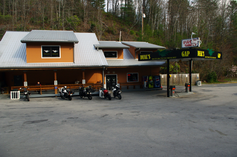
While most of this loop is in Tennessee, we'll start from and then return to the Deals Gap Motorcycle Resort at the North Carolina end of The Dragon, an 11 mile stretch of US 129--legendary for its more than 300 curves and excellent pavement.
A word of caution about the Dragon - don't let all the hype and excitement get you into trouble or you may end up with broken parts hanging from the "Tree of Shame" or worse. Push hard here and the Dragon will push back. Use the numerous paved pull outs to let faster traffic go by. Keep your cool and the ride will be cool. Lose your head and you might not get it back. NEVER, EVER, cross the double yellow line. Bad things happen in a blink at the Dragon.
Leaving the crowds at Deals Gap Motorcycle resort behind, you'll pass from North Carolina into Tennessee within the first mile. Go easy at first and get into the rhythm of the road. You'll find several sections of relatively straight pavement, use them to relax as they lead into tight turns which will catch you off guard if you get too eager with the throttle. Look for the skid marks of those who did not heed this advice and paid the price. Enjoy the ride then pause to savor it with others at the Calderwood Dam overlook.
There are still a couple miles of curves before you emerge from the gap to cruise along the shoreline of several Tennessee Valley Authority dam created lakes. Watch your speed here, it's often patrolled and the excitement from riding the Dragon may still have your adrenaline pumping.
Once US 129 leaves the shoreline, you'll bear left on TN 72 to head north to Vonore. It's a decent ride through mostly unremarkable countryside with a few good curves thrown in.
TN 72 will end when you reach four lane US 411. Turn left to cross over the lake, then watch to turn left onto TN 360 to start your ride south.
TN 360 takes you through more mostly unremarkable countryside on a nice curvy cruise. For those with historic interests, this area once held the capital of the Cherokee Nation at Tanasi from which the state of Tennessee gets its name. The town now lies beneath the lakes though a monument marks the location on a remote shoreline off Citico Road.
TN 360 will lead you to a stop sign at an intersection in Ballplay. Turn left to continue on TN 360 (Ballplay Road) to reach Tellico Plains and the start of the Cherohala Skyway. Top off the tank here if you're low on gas, it will be 50 miles or more before you reach another station.
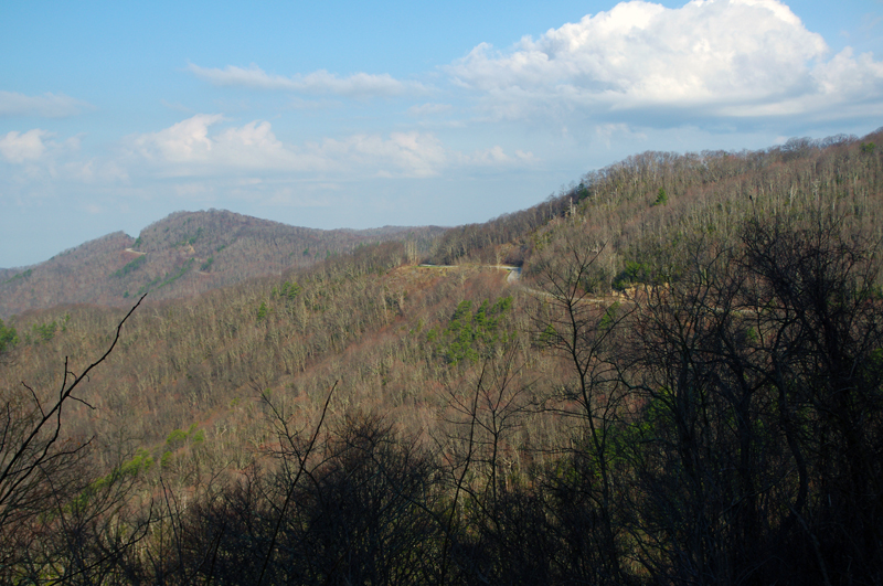
The Cherohala Skyway starts as TN 165. It will become NC 143 one you cross the state line near the mid point. Those who have ridden the Blue Ridge Parkway may experience deja vu - The Cherohala Skyway is remarkably similar in character with sweeping turns, high elevations, and numerous overlooks from which to savor the long range views. If you have a little extra time, you can visit a nice roadside waterfall by using River Road to reach Bald River Falls just a few miles along the skyway out of Tellico Plains. Enjoy the long and scenic ride along the highest ridges of the Snowbird Mountains.
Most riders continue past the end of the Cherohala Skyway on NC 143 which leads into Robbinsville on a very twisty portion of road. Look for the large information sign at the pull out at the end of the skyway, then turn left onto Santeetlah Road. This route bypasses Robbinsville bringing you back to US 129 north of town.
Santeetlah Road will lead out into the forest. When you reach the junction with Joyce Kilmer Road, turn right. A left turn will take you to Joyce Kilmer Memorial Forest where you can enjoy a hike into one of the last remaining stands of old growth forest. The rough road ahead leads out to the Maple Springs Observation Point with commanding views of the surrounding area.
Joyce Kilmer Road will take you on a bumpy, twisty, curvy ride along Santeetlah Lake. The pavement is of lesser quality than that which you been riding so be cautious of gravel in some of the steep tight turns.
Turn left when you reach US 129 - (Tapoco Road) and continue north to return to the Deals Gap Motorcycle Resort. You may recognize a vaguely familiar site, the Cheoah Dam, used for the "jump" scene in the movie "The Fugitive".
Now that you've made the loop and have arrived at the Deals Gap Motorcycle Resort you deserve a T-shirt, a decal, and a nice meal to celebrate your conquest of one of the best rides in the world.
Interactive Map
To use the interactive map, you can click on any of the waypoints for more information (see key below map for details on the different waypoint icon types). You can also click on the route segments for detailed directions. Since we use the Google Maps interface, you can pan and zoom easily. Also, you can drag the "Person Icon" above the zoom bar to the route for a 360° tour using Google Maps Streetview system.
| This Ride Sponsored By: |  |
Map Key:
![]() Start of Ride
Start of Ride
![]() Intersection Marker
Intersection Marker
![]() Scenic Point
Scenic Point
![]() End of Ride
End of Ride
Elevation Profile
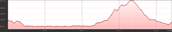
Elevation Information
- Lowest Point: 813'
- Highest Point: 1871'
- Average Elevation: 5371'
Grade Information
- Max Uphill Grade: 11.4%
- Max Downhill Grade: -11.5%
- Avg Grade: 3%
Mile by Mile Directions
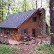
- Mile 0 :: Deals Gap Motorcycle Resort, junction US 129 and NC 28
- Mile 9.3 :: Calderwood Dam Overlook
- Mile 22 :: Turn left onto TN 72
- Mile 31 :: US 411 near Vonore. Turn left to cross over the lake
- Mile 33.7 :: Turn left onto TN 360
- Mile 40.9 :: Citico Road. Leads out to Bacons Ferry Road and Tanasi Monument
- Mile 45.4 :: Ballplay - Turn left to continue on TN 360
- Mile 55.8 :: KOA Tellico Plains - Turn left to start the Tennessee end of the Cherohala Skyway
- Mile 60 :: River Road - side trip to Bald River Falls, (about 5 miles)
- Mile 63.6 :: Whiteoak Flat Road, rough shortcut to River Road
- Mile 78.6 :: North Carolina State Line on Cherohala Skyway
- Mile 90.7 :: North Carolina end of Cherohala Skyway. Turn left onto Santeetlah Road
- Mile 93.1 :: Junction Santeetlah Road and Joyce Kilmer Road. Turn Right. Access to Joyce Kilmer Memorial Forest (left) and Maple Springs Observation Point (straight)
- Mile 99 :: US 129 (Tapoco Rd). Turn left towards Deals Gap
- Mile 107 :: Cheoah Dam
- Mile 109 :: End at Deals Gap Motorcycle Resort
Photo Gallery
Click on a square thumbnail to view a larger image.


Attribution
 This motorcycle ride was contributed by Wayne Busch from America Rides Maps. It is one of many great rides featured on his inexpensive, comprehensive and easy to use motorcycle pocket maps. You may purchase this map and others online at www.AmericaRidesMaps.com.