The Rattler - NC 209
Total Distance :: 32.7 miles
Driving Time :: 45 minutes - 1 hour
Ride Summary : NC 209 has a little bit of everything a motorcycle rider is looking for - pastoral valley views, challenging mountain climbs, twisty and tight technical sections, and a great little mountain town to visit - Hot Springs, NC. A popular weekend ride from Asheville, Maggie Valley, and Waynesville, it can be a lazy roll through the scenic countryside or a place to test the edge of your tires. It's up to you.
Ride Description
NC 209 starts near scenic Lake Junaluska at Exit 104 of the Great Smoky Mountains Expressway (US 74). This first section quickly leaves the semi-urban area behind to follow the Pigeon River north. In 3.5 miles it crosses I-40 at Exit 24, another point to access the south end and begin your ride.
Once across the interstate, it continues to roll out through farmlands in gentle sweeping curves towards the mountainous horizon. The valley narrows and a long climb takes you over the first hump and down into Fines Creek. At the bottom of this first hill, make the well marked sharp right turn at Ferguson's Market to enter the next valley section.
Roll along the stream for 1.5 miles then start the twisty climb over the first mountain. Nice curves across the mountain top wind through forest and homes with a few good views, but keep your attention on the road. Watch for gravel in the turns which are sharp and challenging for the next 4.5 miles.
The gradual descent off the mountain brings you to another valley as the road traces the winding course of another stream and rounding a curve you'll arrive at the junction with NC 63 at Trust.
A few more curves through the woods bring you to the long straight section of road which crosses broad Spring Valley. Enjoy the break from the twisty sections, it's short lived. The valley soon narrows and the road rejoins the stream winding and twisting along it for the next several miles.
A sharp hairpin turn starts the last section of NC 209 as it climbs to enter the national forest. It's a tight and technical ride through sharp and challenging curves that will rival the most challenging roads you can find. Be vigilant for gravel in the hairpin curves, some of which will have you dropping into first gear. There are a couple unpaved overlooks along the road.
Arriving in historic Hot Springs, you'll find several good places to grab a meal and take a well deserved break. The 2000 mile long Appalachian Trail passes through town, you may see some of these marathon hikers. On any nice weekend you'll share the company of numerous motorcycle riders who make the ride from Asheville and Tennessee. If you have the time, visit the Hot Springs Spa to enjoy a soak in the natural hot springs that give the town its name.
Interactive Map
To use the interactive map, you can click on any of the waypoints for more information (see key below map for details on the different waypoint icon types). You can also click on the route segments for detailed directions. Since we use the Google Maps interface, you can pan and zoom easily. Also, you can drag the "Person Icon" above the zoom bar to the route for a 360° tour using Google Maps Streetview system.
| This Ride Sponsored By: |  |
Map Key:
![]() Start of Ride
Start of Ride
![]() Intersection Marker
Intersection Marker
![]() Scenic Point
Scenic Point
![]() End of Ride
End of Ride
Elevation Profile
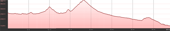
Elevation Information
- Lowest Point: 1329'
- Highest Point: 3887'
- Average Elevation: 2492'
Grade Information
- Max Uphill Grade: 15.5%
- Max Downhill Grade: -10.3%
- Avg Grade: 4.0%
Mile by Mile Directions
- Mile 0 :: NC 209 begins near Exit 104 on the Great Smoky Mountains Expressway
- Mile 3.5 :: NC 209 can be accessed here using exit 24 I-40 as well
- Mile 8.1 :: Take a sharp right at Ferguson's Market to continue on NC 209 (Betsy's Gap Rd)
- Mile 18.2 :: Junction of NC 209 and NC 63 at Trust
- Mile 32.7 :: Arrive in Hot Springs
Attribution
 This motorcycle ride was contributed by Wayne Busch from America Rides Maps. It is one of many great rides featured on map #6 ("The Best Motorcycle Rides Near Smoky Mountains National Park - EAST") in the Blue Ridge Parkway series of Motorcycle Maps. You may purchase this map and other America Rides Maps at the Virtual Blue Ridge Bookstore.