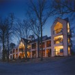
Hampton Inn and Suites - Cashiers Sapphire Valley
Greetings Fellow Motorcyclists! Our friends at The Hampton Inn and Suites of the Cashiers/Sapphire Valley in North Carolina are offering an exclusive offer to stay in their private mountain retreat by staying with them before March 31st, 2012.
Their fabulous Mid-Winter Valley Special is meant to lift your spirits and remedy cabin fever. The special price offer is $79/night (Friday to Saturday) and $69/night (Sunday to Thursday). The price includes all applicable taxes and the standard hotel amenities. The only way to get the special rate is to call the hotel directly at 828-743-4545 and ask for the Winter Valley Special!
The area boasts several warmer days for riding your motorcycle in late winter and early spring as it is in the lower elevations on the eastern escarpment of the Blue Ridge Mountains about 40 miles south of Asheville, NC. Our Wild Dam Waterfall Loop goes right in front of Hampton Inn and Suites and makes for a great starting point for a tour through the "Land of Waterfalls." Situated right off of Hwy 64 East in Sapphire, NC, the curvy mountainous ride will please in and of itself.
You'll enjoy beautiful and comfortable rooms and suites with modern convenience in a quaint mountain setting at the Hampton Inn and Suites. Standard king or queen rooms are available, as well as king and queen studios and suites. Many rooms have mountain views! All rooms have microwave and mini-fridge, free wireless Internet access, coffeemaker, hairdryer, iron and ironing board. There is also a complimentary hot breakfast and beverages; indoor pool and whirlpool; fitness room; Business Center and meeting facilities.