Smoky Mountains Adventurous Spring Motorcycle Ride Photos

Photo - Soco view

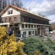
Morning view on Soco Rd - Click on pics for LG view

15 minutes from home and already I was fighting the urge to jump off the motorcycle and start snapping pictures. It was a beautiful Smoky Mountain spring morning. Rounding every curve the canvas repainted another fabulous scene as I droned down from the Blue Ridge Parkway at Soco Gap towards Cherokee.

Photo - view from Clingman's Dome

Clingman's Dome view

Not a car on the road ahead of me, I let the bike stretch it’s legs through the curves effortlessly riding every last inch of rubber as my Triumph Tiger charged down the incline in pursuit of it’s prey.

Photo - view from Roaring Fork Rd

Roaring Fork Road - must be Roaring Fork!

It felt so good, all is right with the world when you’re on your motorcycle in the mountains. Wrapping around a rock face with the mellow grace of a cat arching it’s back, I flicked left to begin my plunge to the valley floor on the first of the new roads I’d see today.

Photo - hairpin curve on Alpine Rd

Alpine Rd - one of my newest favorites

How had I missed this road? I’ve bypassed it many times on my passages to Cherokee. It’s not like I haven’t studied the area and it’s so close to home. Yet when we came through on a motorcycle ride Saturday, a road I was vaguely familiar with suddenly jumped out at me and said, “Come back and take a closer look”.

Photo - Cherokee Orchard Rd

Cherokee Orchard Road Overlook

The clue  that tipped me off  was the name – “Old Soco Road”. It suggested I was riding the “new” Soco Rd (US 19). “Old” Soco Rd was the way things used to be. Sometimes these “old” roads are gems.

It was like riding off a cliff and I had to quickly adapt to the more primitive road surface. Gliding through turn after turn I delicately parachuted through the  loose gravel and the windblown debris that had rained down on the switchbacks on this third day of roaring mountain wind. April was coming in with a bang.

Photo - Old mill

I passed this old mill again today

So began a day that took me across Great Smoky Mountains National Park and out into the wilds to the north as I clicked off road after road on my search for the best motorcycle rides. The afternoon would bring me into a violent storm navigated on what were now familiar byways through seemingly remote and isolated hidden valleys where angry streams threatened to crest their banks and wash across the pavement.

Photo - Tapoco Dam

The Dam at Tapoco

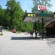
Looping around the west side of Great Smoky Mountains National Park near the end of the day, I’d arrive at Deals Gap to find the motorcycle resort closed due to the lack of electricity as a wind blown forest fire raged up a flank of the park consuming the lines and felling trees in it’s path. I’d squeeze through a gap between the fire trucks parked on a back road to ride through the smoke and smolder where crews fought the flames and mended the wires.

As the day drew to an end the lightening and rains caught up to me again, followed me home bringing the fury of the storm with them, and toppled trees that would have me without power for the next few days.

I’ve lost a couple days of work and will now double-down to make it up. With each new day the grays and browns of winter give way to the soft pastel greens of emerging leaves as spring wrestles the cold grip from the old season to bring the warm blooms of the new.  The fuse is lit for the explosion of color. It’s time to point your wheels towards the high country, its ready for you.

The Birthplace of Tennessee – Best Seen on a Motorcycle

Photo - marble campfire

Who knows where this is?

It was the middle of nowhere yet it was the center of everything. I’d stumbled upon the birthplace of Tennessee.

I had low expectations. My research told me most of the roads I’d be riding today would hold little interest to the typical motorcycle rider who had come to ride The Dragon at Deals Gap and the Cherohala Skyway. None of the roads I’d ride on my 450+ mile travels would come anywhere close to those legends. Still, the morning held a surprise I never expected and made the efforts worthwhile.

Photo - Cherokee National Forest Road

Parked along Pleasant Mountain Road. It's typical of other roads nearby - of little interest to most. Still I check them all.

Arriving in Tellico Plains, Tennessee, after an early morning motorcycle ride where I’d had the whole of the Cherohala Skyway to myself, I pointed my wheel north onto TN 360 and my workday began. Within a few miles I’d reach the point where I’d previously abandoned my search for great motorcycle rides and the explorations would resume. Rounding a curve a green street sign flashed past with a name I recognized and I clamped on the brakes to swing around.

I could rule this road out as soon as I saw it, it was doubtful it would be of any interest. Consulting my map, I saw it connected to another I wanted to investigate, so I snicked into first gear determined to make quick work of White Plains Road and move on.

Photo - Tanasi Monument

The Tansi Monument - Tennessee gets it's name from here

It met Smoky Branch Road in a few miles where they both intersected Citico Road. I’d eventually loop back through Smoky Branch Road, also of little interest. Obviously Citico Road was the daddy in this area, the main thoroughfare of better quality, decent pavement, and sporting a faded double yellow line, a proper road.

I expected it would quickly peter out, but after several miles it continued to wind and snake through the mostly bland countryside and I started to wonder if it actually went somewhere in the big empty white space on the map. Curiosity aroused, I couldn’t resist investigating the Tanasi Memorial Site when the sign appeared.

Photo - Tanasi Monument

The empty and isolated setting quickly fills with visions of what must have been

Never heard of it. Turning the motorcycle onto Bacon Ferry Road I ventured out into the nothingness on the barely paved bumpy and potholed  single lane that led out onto a low finger of land surrounded by Tellico Lake. I rode past the pull-off, but a quick glance towards the lake had me circling back when I saw the shoreside monument.

Photo - Tanasi inscription

Inscription transcribed below

Tanasi

Capital of the Cherokee Nation

1721-1730

Origin of the Name for the State of Tennessee

The site of the former town of Tanasi, now underwater, is located about 300 yards west of this marker. Tanasi attained political prominence in 1721 when its civil chief was elected the first “Emperor of the Cherokee Nation”. About the same time, the town name was also applied to the river on which it was located. During the mid 18th century, Tansi became overshadowed and eventually absorbed by the adjacent town of Chota, which was to the immediate north. The first recorded spelling of Tennessee as it is today occured on Henry Timberlakes map of 1762. In 1796, the name Tennessee was selected from among several as most appropriate for the nation’s 16th state. Therfore, symbolized by this monument, those who reside in this beautiful state are forever linked to its Cherokee heritage.

Pho

Cherokee Tanasi to Tennessee - State. A heritage preserved and honored.

I don’t much adhere to theories of “vortexes” or spirituality, but there’s something about this site that is powerful enough to make it worth a visit, it will be on the new map. It’s worth the ride out to it. See it if you have the chance.

Motorcycle the Dragon, the Cherohala Skyway, the Blue Ridge Parkway in one day

Photo - Thermometer at Deals Gap Motorcycle Resort

Thermometer at Deals Gap Motorcycle Resort

It was 80 degrees when I pulled up at the Deals Gap Motorcycle Resort yesterday at 5 PM with over 400 miles of Smoky Mountain motorcycle rides already behind me. 8 hours ago I was on the Cherohala Skyway as the soft morning glow and gusty winds made the lonely road seem like it was in another world.  I decided to make the day a trifecta and go home via the Blue Ridge Parkway. It’s hard to believe it’s still March, early spring has arrived!

Photo - morning on the Cherohala Skway

Morning on the Cherohala Skyway. I'm parked on the state line between North Carolina and Tennessee.

I had reservations about going out today, I’d been putting it off. I knew I would not find many good motorcycle rides in the areas I was searching. It was either too far out of the mountains or too far to into them. I was hitting the single lane back roads in the National Forests near The Dragon at Deals Gap and the Cherohala Skyway,  as well as the best ways to pass through the semi-urban areas to the north.

Photo - marble campfire

Who knows where this is?

I found something cool out in the Cherokee National Forest that will get it’s own motorcycle blog post shortly. One of the more useful things I discovered is one of the most direct ways to connect The Dragon at Deals Gap to I-75 south of Lenoir City.

Photo - Cherohala Skyway View

A long view of the Cherohala Skyway as it winds into Tennessee

I suspect many riders follow US 129 to Maryville, then take US 321 north when headed for the Interstate. There is  a way to minimize the traffic and avoid more than half of the four lane US 321.

Take TN 72 north from The Dragon at Punkin Center. When you reach US 411, cross it onto the East Coast Tellico Parkway and follow it along the lake area. It will become Axely Chapel Road at the north end and will intersect US 321. These are not outstanding motorcycle rides, but they are a heck of a lot better than the alternatives and get you off the four lane on some scenic and curvy motorcycle roads.

Photo - Calderwood Lake

Calderwood Lake is one of several along US 129

I don’t really care much for riding in this area, but it’s only because there are so many really great motorcycle rides once you get in close to Great Smoky Mountains National Park. It’s hard to shine when pitted against them.

I’ve been mostly focusing on find the connections between the better rides so you can link them together. If you have the time when passing through, they are the most enjoyable motorcycle rides I can find for those who would rather stay on the back roads and savor them. The views are certainly more entertaining. Watch out for turkeys in the road.

Photo - Chillowhee Dam

How many of you have seen the Chillowhee Dam from this side?

My “wake up and dream” cruise on the smooth and sweeping curves of the Cherohala Skyway was the highlight of the morning.  The rest of it was on a web of roads which weave through the more remote and rugged sections of the national forest. A few of them start out as decent paved roads, but quickly diminish to single lane unmarked trails that become more potholed and full of gravel as you go. On most, the pavement ends long before the road does.

Photo - motorcycles at Delas Gap Motorcycle Resort

5 PM on a Tuesday evening in late March at the Deals Gap Motorcycle Resort

I’ll need at least one more good day to cover this area as thoroughly as I’d like. I’ve hit almost all the roads. The challenge now is how they work together to become the best motorcycle rides through the area, how well do the linked roads flow, can I find ways to make the good motorcycle rides last longer?

I know I can!

(Click on photos for larger views)

My Search for the Best Mountain Motorcycle Rides Never Ends

Photo - Maple Springs Observation Point

The Maple Springs Observation Point - accessed from Santeetlah Rd

Friday’s search for great Smoky Mountain motorcycle rides, which culminated with a spirited cruise on the Cherohala Skyway, was one of those days that might be looked on as not so productive. It’s not that I didn’t catalogue some good mountain motorcycle riding roads, I added several which will appear on my new map of the area. In my quest to leave no stone unturned, much of the 400 miles I covered was spent on roads which only the most adventurous would bother to travel. Still, there are sights and places some may wish to see, and I’m determined to find as many of them as I can.

Photo - Cherokee National Forest View

View from the Maple Springs Observation Point. I was told you can see 5 states from this spot.

Considering the number of motorcycle riders who are drawn to the area by such notable roads as The Dragon at Deals Gap, the Cherohala Skyway, The Tennessee Foothills Parkway, NC 28 (now renamed “the Moonshiner 28“), finding others that compare in quality is pretty much futile. These are some of the best motorcycle rides in the world. I’m not holding my breath thinking I’m going to discover the next great classic motorcycle ride. So why go to all this effort?

Photo - Santeetlah Dam

Quiet morning at the Santeetlah Dam

There are probably millions of motorcycles that pass through here each year. In most cases, they come, they ride the famous roads, get the t-shirt, then they’re gone to other places following the crowds. It’s the notable roads that get all the attention. Once experienced, it’s back on the four lane or the congested tourist arteries to reach the next great spot. You can rack up a lot of miles playing connect-the-dots, though those droning plods on the connections are the price you pay to reach those popular motorcycle rides.

Photo - Bald River Falls

Bald River Falls

It doesn’t have to be that way. I’m filling in the gaps between the famous motorcycle rides with the best quality rides I can find so connecting the dots is as much of an adventure as the roads you’re trying to reach. Where others might show you one good way to get from point A to point B, I look for all the best ways.

Photo - Cherohala Skyway View

View from the Cherohala Skyway. The Smoky Mountains were especially smoky today and I'll get more photos another time.

Who want’s to spend their time on the 4 lane or in bumper to bumper tourist traffic when there are so many empty two lane scenic and challenging mountain roads that get bypassed? It’s often as simple as crossing over to the next valley to escape the congestion. One little turn can make the difference between cruising along with the wind in your face or cursing the throngs of dawdling codgers, gawking sightseers, lumbering RV’s, and belching commercial trucks struggling up the grades to deliver their wares.

Photo - Motorcycles on the Cherohala Skyway

Bikes on the Cherohala Skyway

I’ve catalogued more than 100 good motorcycle roads so far surrounding Great Smoky Mountains National Park. I’m not done yet. Some of these are outstanding rides. Others will satisfy those looking for adventure. All of them avoid most everyone else who’s come to enjoy the Smoky Mountains just like you and take you to the places they’ll never see while getting you where you want to be.

Keeping you going is what keeps me going. I’m closing in on finishing the map of the Best Motorcycle Rides North of Great Smoky Mountains National Park. Stay tuned and see what I discover. It’s all for you. (Click on the photos for the large versions)


http://www.youtube.com/watch?v=xBbQfR2GqMc